
All of us engaged in this project approached “The Baltimore Collection” from different perspectives and disciplinary backgrounds. Much of our discussions about the collection centered around archival practices as we discussed the process of creating metadata to be associated with the photographs on Artstor. However, as an art historian passionate about the visual history of the city of Baltimore I was always most drawn to the process of researching and writing about the photographs themselves. Correspondingly, as I look forward at the afterlife of our work on the Baltimore Collection, I am interested in the promise of what these photographs can tell us about Baltimore and its residents at the turn of the twentieth century.
Our research reveals photographers and studios moving between addresses, as well as different studios operating at the same address under different operators—exposing longitudinal links both between the Baltimore Collection and across time. Specifically, the Baltimore Photographic Company and later Harry Plumley both separately operated studios at 588 N. Gay Street in Baltimore, from 1896-1899 and 1904-1911 respectively. Taken perhaps decades apart, these photographs are material evidence of a complex network of photographers and African American sitters existing in Baltimore in the years surrounding the turn of the twentieth century. Identifying these affinities between the photographs makes their connections legible and makes further research on those connections possible.
This map shows the known locations of the Baltimore Collection studios based in Baltimore. Inherently, it is incomplete: many Baltimore Collection photographs do not have listed studios, and for some that do it is impossible to positively identify where they were operating. However, plotting out the studios we can identify allows us to ask new kinds of questions of these photographs. It becomes apparent that these studios are concentrated in a central downtown area, one heavily redeveloped in urban renewal efforts of the mid-twentieth century. [1] Google Maps shows us that sometime in the intervening century, 588 North Gay St. and the surrounding blocks were leveled and replaced with a courthouse. What was this neighborhood like when the photographs of the Baltimore Collection were made? What did our unidentified sitters see as they traveled through it?
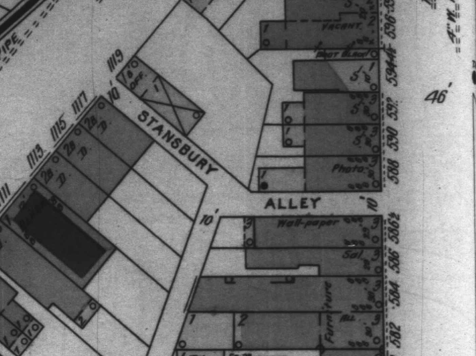
Detail of digitized microfilm page of 1901 Sanborn Fire Insurance map of Baltimore showing 588 N. Gay St. as a photography studio. Courtesy Maryland State Archives, Sanborn Map Microfilm Collection, MSA SC 2907
We have some tools to help us answer these questions. The Sanborn Fire Insurance company’s exhaustive 1901 map of Baltimore shows 588 North Gay St. as a photography studio surrounded by storefronts, some of which we can see sold wallpaper and furniture. Behind 588 North Gay St. were a row of residences (labeled “D.,” for “Dwelling”).[2] Yet, these scraps of information just lead to more questions–who lived in those dwellings? Did our sitters shop at those stores? Even the 1901 publication of the map is enigmatic. We know about the connection between the Baltimore Photographic Company and Harry Plumley’s studio because of their presence in “The Baltimore Collection,” but in 1901 neither studio was operating at 588 North Gay St. Someone’s studio clearly was; whose?
Sources
- For more about Baltimore redevelopment, including extensive photographs of neighborhoods before and after construction, see: Marion E. Warren and Michael P. McCarthy, The Living City: Baltimore’s Charles Center & Inner Harbor Development (Maryland Historical Society, 2002).
- “Sanborn Map Abbreviations.” Accessed December 9 2017 http://web.mit.edu/thecity/resources/abbreviations_for_sanborn_maps.pdf
