
Tuesday, December 11, 2018
Location via mapsHosted by UD GIS. All are welcome to attend. Coffee and doughnuts will be provided. Those unable to attend can join via Zoom.
MEETING AGENDA
Presentation by Andrew Homsey, from UD’s Water Resources Center: Embracing On-line Mapping: A Case Study.
- Roundtable discussion
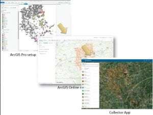
In this coffee hour, Andrew will present a small case study in on-line data collection and mapping in support of the Newark Source Water Protection Plan–mapping the farms in the White Clay Creek watershed–as a framework to highlight some of the shifts in the spatial technology paradigm. This example will also point out some issues and observations on the process and how practitioners need to adapt and innovate, particularly as a new generation of geospatial professionals comes up, which has grown up under this new paradigm.
Andrew Homsey
Web-based mapping and spatially enabled applications are changing the way the world works, and the way that we as GIS professionals function.
The enabling technologies for this shift include robust web standards, a wide variety of powerful, sophisticated APIs, cellular broadband and other high-speed wireless modes of connectivity, social sharing platforms that enable information propagation and crowd sourcing, and ubiquitous GPS integration.
The shift from node-locked workstation based desktop applications, to a shared, platform-independent, and massively connected system, requires that many GIS professionals reshape their thinking of the future.
This meeting is intended to be largely interactive: we hope that you bring your experiences, questions, issues, and case-studies for us to look at and discuss in open forum.